ACTIVE PROJECTS
Geomorphometric Controls on Minibasin Morphology
Co-authors: Dr Wonsuck Kim, María Paula Borja Tibaduiza, Dr Chenliang Wu, and Esoo Yun.
Institution: Yonsei University Department of Earth System Sciences.
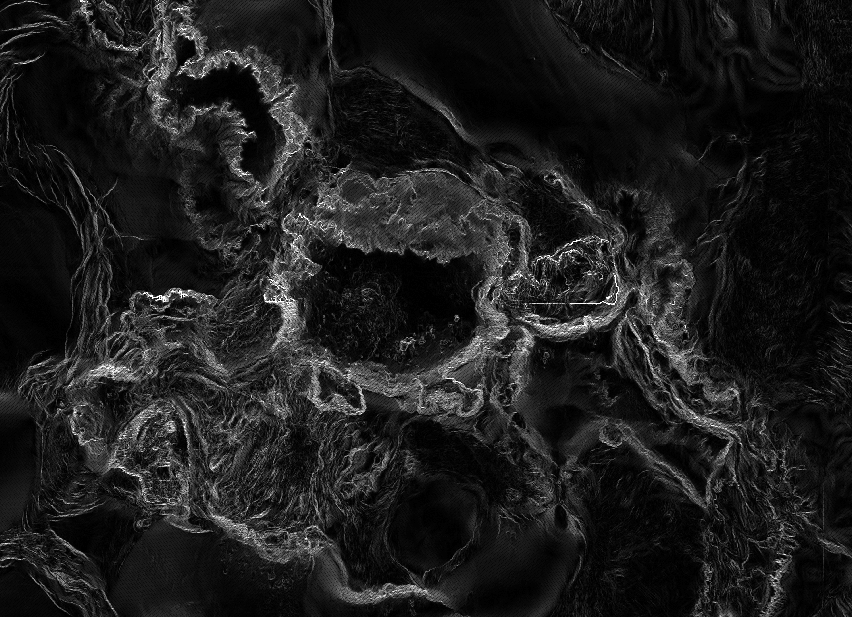
Minibasins are halokinetic structures which are the product of differential sediment loading atop a ductile salt substrate. Their subsidence is driven via the coevolution of depositional and tectonic processes. Minibasins have a global distribution, including dominating the northern deepwater Gulf of Mexico basin. Through the employment of a 12 m resolution bathymetry dataset of the northern deepwater Gulf of Mexico acquired from 3D seismic by the US Bureau of Ocean Energy Management (BOEM), in conjunction with numerical modelling of salt response to perturbations, this investigation seeks to derive the mechanisms by which differential sediment loading in a complex natural environment with variable salt substrate thickness induces differing rates and magnitudes of minibasin subsidence, and how the interplay of these processes affects the resultant minibasin morphology.
Fig. 1. Slope map derived from 12 m BOEM bathymetry of the Beaumont minibasin bisected by the Bryant Canyon turbidity channel complex.

Fig. 2. Processing recently acquired multibeam echosounder (MBES) data on CARIS from our forward operating base.
(2019)
Bedload Transport During Floods
Co-authors: Dr John Goff, Dr Eric Prokocki, Dr David Mohrig, Dan Duncan, and Marcy Davis.
Institution: The University of Texas Institute for Geophysics.
By utilizing multibeam echosounder (MBES) surveys taken of the Brazos River by the Institute of Geophysics during two separate instances while the river was in flood stage, combined with seismic/CHIRP data, acoustic Doppler current profiler (ADCP) data for flow velocities, and sediment samples for grain size analysis, we can investigate fluvial bedload transport during flood events and conduct a complete bedform morphology study of the Upper and Lower Brazos River during floods, the first study of its kind. Successfully surveying while a river is in flood stage is almost unheard of. Initial analysis of bathymetric surveys indicate significant bedform migration during the flood events, contrary to surveys done by the US Army Corps of Engineers during ambient conditions, which found almost no sand bedload. This study shall shed light on where the sand which is building the Brazos delta and adjoining beaches is coming from, and so bears significant implications for our understanding of coastal processes.
Deltaic Response to Climate Induced Base Level Change
Co-authors: Dr Cornel Olariu, and Dr Mark Helper.
Institution: The University of Texas Department of Geological Sciences.
My first independent research project primarily focused on studying the fluvial/deltaic response to changing boundary conditions. To that effect, I’m currently leading an investigation within the Dynamic Stratigraphy Research Group on the effect of base level change due to glacio-eustatic sea level rise driven by changing climate conditions on deltaic off-shelf deposition, the project being centred on the Late Quaternary Mississippi River delta, with hopes to expand to a globe encompassing database of similar aged river deltas in the future. Therein, I’m examining the delta’s sediment dispersal during transgression and regression by means of determining how the locus of deposition of the Mississippi has fluctuated since the last glacial maxima (LGM) via mapping and calculations of the volume of sediment deposited on-shelf by the Mississippi since the LGM. I’m then quantifying the volume of off-shelf sedimentation through stages of sea level rise by deducting the volume of the mapped on-shelf deposits from sediment discharge models created by using water discharge and climate models.

Fig. 3. Elevation map of the base of the substratum within and offshore of the Lower Mississippi Valley deposited during the rapid base level rise subsequent of the LGM.
PAST PROJECTS

Fig. 4. The Kolyma Delta, as seen in a false colour RGB timeseries from GRD processed VV polarised Sentinel-1 C-SAR.
Machine/Deep Learning Arctic Delta Morphodynamics
Co-authors: Dr Anastasia Piliouras, Dr Jon Schwenk, and Dr Joel Rowland.
Institution: Los Alamos National Laboratory EES-14.
Devising a means by which to track ice retreat associated with the spring flood within arctic deltas, shall enable more accurate modelling of the effects of ice cover on the spatial and temporal distribution of riverine fluxes to the coastal oceans. To this end, a process was formulated by which to autonomously classify ice cover within the Kolyma Delta at a high temporal resolution through the development of a random forest machine learning algorithm which employed Interferometric Wide C-band synthetic aperture radar (C-SAR) acquired via the Sentinel-1 satellite constellation from the European Space Agency (ESA)’s Copernicus Programme. Validation by means of confusion matrices confirmed the high levels of accuracy achieved via this method.
The Geomorphological Effects of Hurricane Harvey and Hunting the Lowstand Nueces River Valley
Co-authors: Dr Sean Gulick, Dr John Goff, Dr Chris Lowery, Dan Duncan, Marcy Davis, Steffen Saustrup, Chujie Liu, and Tharit Tangkijwanichakul.
Institution: The University of Texas Institute for Geophysics.
See Field for further details on my experience on the UT Institute for Geophysics Marine Geology and Geophysics expedition in the Gulf of Mexico.
Linking Submarine Canyon Formation to Regional Tectonics
Co-authors: Austin Clayton, and Dr Cornel Olariu.
Institution: The University of Texas Department of Geological Sciences.
For my first research project, employed Neuralog to work with gamma ray and neutron porosity well logs from the Yoakum Canyon on Austin Clayton’s Master’s Thesis about linking Gulf of Mexico submarine canyons with regional tectonics associated with the Laramide Orogeny.
GIS Programmer & Software Engineer
Institution: Railroad Commission of Texas Groundwater Advisory Unit.
As a GIS programmer/software engineer within the Groundwater Advisory Unit, a groundwater protection agency, employed Python and ArcGIS to create models and execute complex transformation scripts on large agency wide geospatial databases of all known well logs in Texas. Further initial work was undertaken to develop relational databases on Access to normalise the large data set, before laying the groundwork for a transition to Oracle near the end of my term.