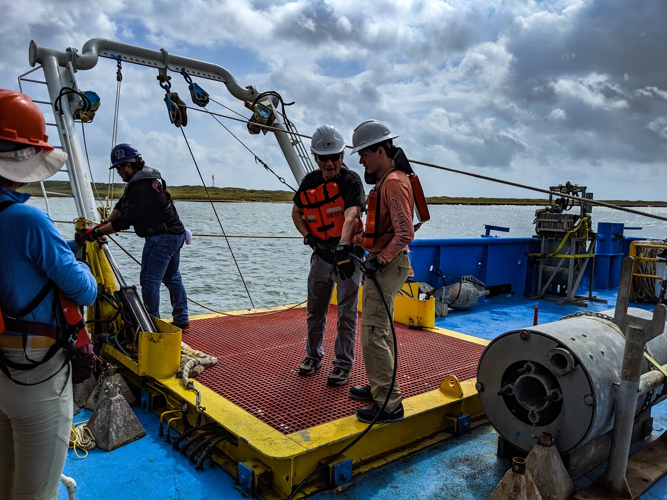

Fig. 1. Paying out the hydrophone streamer aboard the R/V Brooks McCall on Day 6 of the UTIG expedition to the Gulf of Mexico (I’m the one wearing the orange shirt and white hard hat). The streamer is a buoyant assemblage of hydrophones towed behind the vessel which record pressure changes in the water by generating an electrical potential when subjected to a pressure change. These receivers record how long it takes for the sound waves generated by an airgun to reflect off of interfaces of acoustic impedance and return to the surface. Sound waves reflected off of different interfaces arrive at the hydrophones at different times, thereby allowing us to view the subsurface.
(27 May 2019)
UTIG, Marine Geology and Geophysics Expedition in the Gulf of Mexico, May – Jun. 2019
Over the summer of 2019, I served as a crew member and geophysicist aboard the University of Texas Institute for Geophysics’ Marine Geology and Geophysics expedition to the Gulf of Mexico where we collected, processed, and interpreted multibeam bathymetry, side-scan bathymetry, seismic, and chirp data, in addition to collecting and performing sedimentological analyses on piston/push/box cores and grab samples aboard the R/V Brooks McCall and the R/V Scott Petty over 3 weeks, in order to map the lowstand Nueces River valley from the Last Glacial Maxima, and to investigate the geomorphological effects that Hurricane Harvey, which struck the Texas coast in 2017 as a category 4 hurricane, had inshore and offshore of the Corpus Christi Bay. By combining these different datasets with data collected from before the storm, and by studying the bedforms on the ocean floor and the ebb flow channels that the storm had carved into the barrier islands, I was able to deduce the path and flow velocity of the hurricane’s return flow, which our team presented to sponsors.
To learn more about the expedition and see more photos with helpful descriptions, click here and then click “Feed View”.
The University of Texas, Bastrop (USA), Oct. 2018
Utilised GIS to accurately map contacts between Tertiary terrigenous clastic units, and map the location and orientation of changes within the geometry of the units.
The University of Texas, Pedernales Falls State Park (USA), May 2018
Mapped and described sedimentary structures within Pennsylvanian limestone and sandstone units, and mapped the geometry of a carbonate buildup within the limestone unit.
The University of Texas, Austin (USA), Apr. 2018
Measured sections of a Cretaceous limestone unit at multiple localities, and determined lithofacies and correlations between sections.
The University of Texas, Bastrop (USA), Mar. 2018
Mapped and described Tertiary terrigenous clastic units and identified river pebbles from outcrops for provenance determination.
The University of Texas, Llano & Inks Lake State Park (USA), Mar. 2018
Mapped and described folded Precambrian marbles and the geometry of a Cambrian/Precambrian nonconformity within the Llano Uplift.
The University of Texas, Marble Falls (USA), Feb. 2018
Mapped and described Pennsylvanian and Quaternary turbidite units.
The University of Texas, Mason Mountain Wildlife Management Area (USA), Feb. 2018
Mapped the geometry of a Cretaceous/Precambrian nonconformity within the Llano Uplift.
The University of Texas, Austin (USA), May 2017
Identified invertebrate marine fossils within a Cretaceous chalk unit at multiple localities, including Ammonoidea, Heteraster texanus, Inoceramidae, Exogyra ponderosa, Exogyra tigrina, Lispodethes texana, serpulid worm tubes, etc.
The University of Texas, Llano Uplift (USA), Oct. 2015
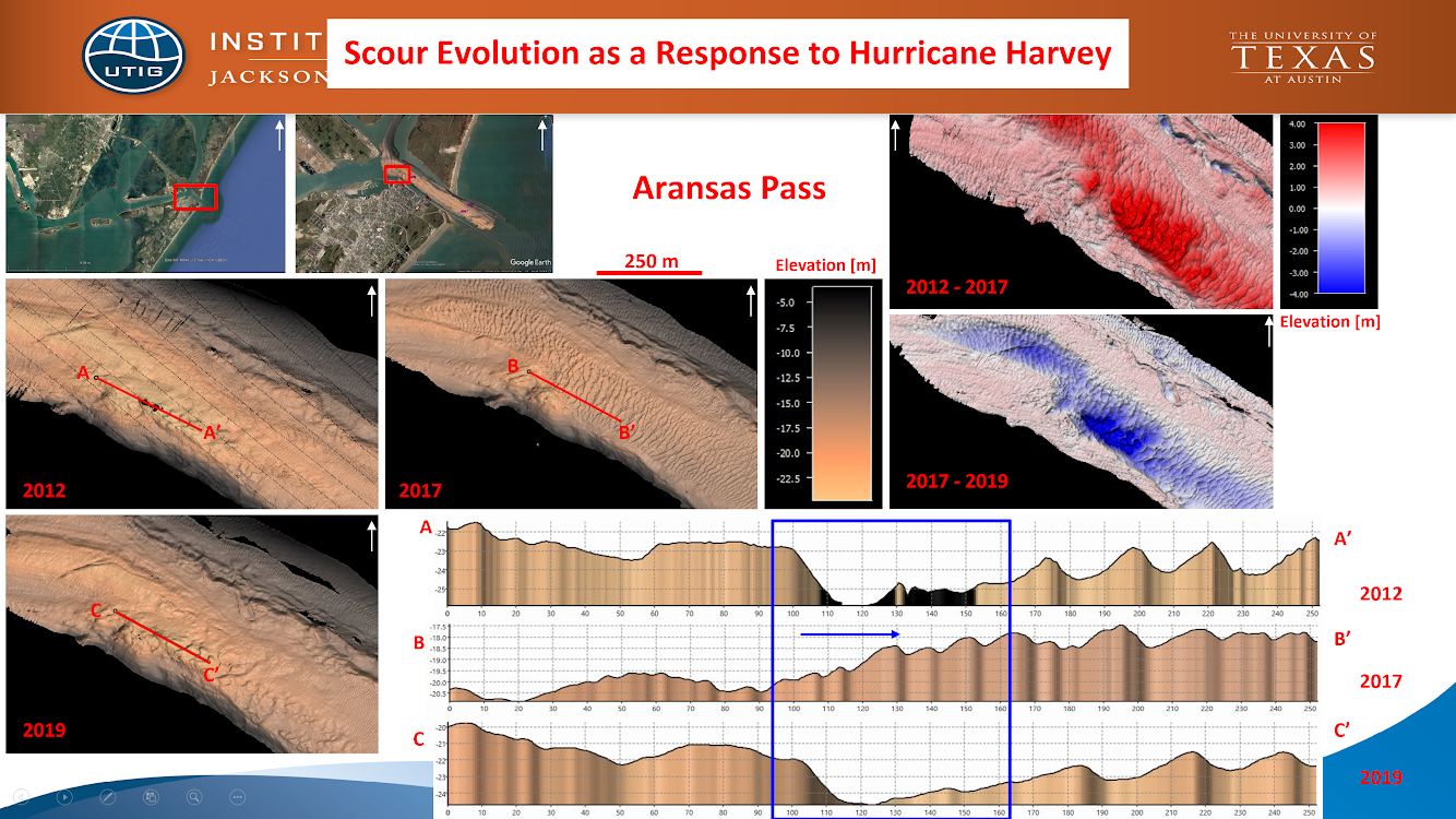
Fig. 2. Part of my analysis of the evolution of scours seen within the Corpus Christi Bay, as a result of Hurricane Harvey, which I utilised to deduce the path and flow velocity of the hurricane’s return flow.
(Presented on 10 Jun. 2019)